

Every clearance you give is built from a small vocabulary: a direction, a speed, an altitude, and a position on the scope. Chapter 1 let a radio exchange go past without explaining it. This chapter teaches the units those exchanges were made of, so that every transmission from here on makes sense as you hear it.
Headings and the compass
Direction in the sky is given as a heading. A heading is a point on the compass rose, spoken as three digits, from zero zero one through three six zero. East is zero nine zero, south is one eight zero and west is two seven zero. North is spoken as three six zero. It is never spoken as zero, because zero on its own means no heading at all.
A heading is always three digits, including headings below one hundred. A heading of forty degrees is spoken as zero four zero. Say all three digits every time; a shortened heading leaves the pilot to guess the missing digit.
Speedbird Four One Zero, turn right heading two seven zero.
Right heading two seven zero, Speedbird Four One Zero.
The words left and right in that instruction carry information. Turn right heading two seven zero and turn left heading two seven zero bring the same aircraft to the same final heading by two different paths. The path is often the reason for the instruction in the first place, because the turn has to keep that aircraft clear of another one while it is turning.
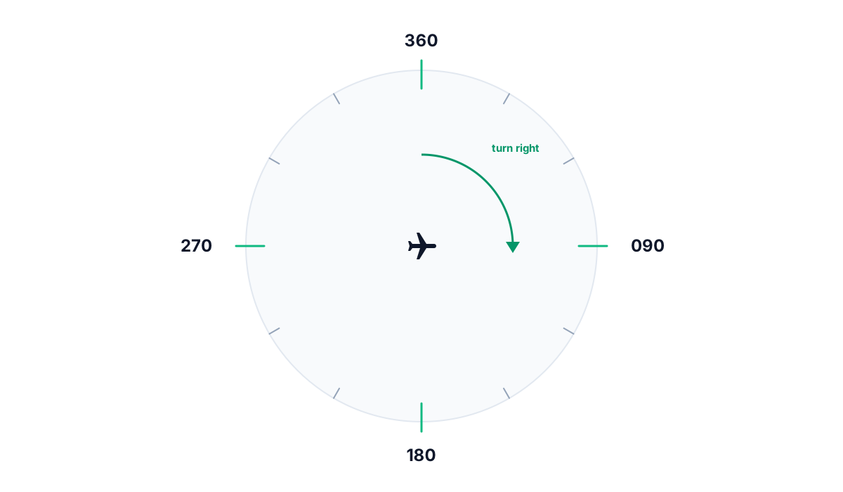
Runway numbers come from the same rose. Bayview's runway two five right points close to heading two five zero, and runway three three points close to three three zero. Which runway is in use is the tower's decision and depends on the wind. The numbers themselves are magnetic headings rounded to the nearest ten degrees, and every heading you assign is magnetic as well.
Units of the sky
Three units carry almost every number you say on frequency.
- The knot is one nautical mile per hour. It is the unit for airspeed and for groundspeed.
- The nautical mile is one minute of latitude, about 1.15 statute miles. Charts are drawn in nautical miles, so it is the one distance you can read straight off the map.
- The foot is the unit of altitude. Below the transition it is counted up from sea level, and above the transition it is counted from a shared standard pressure.
Airspeed and groundspeed are different numbers, and the difference is the wind. A jet flying at 250 knots of airspeed into a 50 knot headwind crosses the ground at 200 knots. With the same wind behind it, the jet covers the ground at 300 knots. Your radar shows groundspeed, because groundspeed is what the radar returns measure. The pilot's instruments show airspeed, because airspeed is the number that keeps the wings flying. When you assign a speed on the radio, you are talking about the number the pilot can act on, and the two figures are rarely the same.
United Eight Eight Two, reduce speed to one eight zero.
Reducing to one eight zero, United Eight Eight Two.
Altitudes and flight levels
Altitude is measured in feet, and the instrument that measures it is the altimeter. An altimeter is a barometer. It reads pressure, and it only gives a useful height once it has been set to agree with the air around it. At low altitude, where you and every aircraft in your sector need to agree with the ground and with each other precisely, everyone sets the same local pressure, called the altimeter setting. Altitudes then read out as feet above mean sea level, or MSL. Descend and maintain five thousand means five thousand feet MSL.
At high altitude the local pressure matters less, because nobody up there needs to know their height over a runway fifty miles away. Above a set altitude called the transition altitude, every aircraft switches from the local pressure to the same standard pressure, and altitude is then read as a flight level instead of in feet. Climb and maintain flight level three five zero means 35,000 feet on the standard setting. That may not be 35,000 feet above sea level, but every other aircraft up there is reading the same standard. Two aircraft at flight level three five zero and flight level three four zero are 1,000 feet apart on the standard setting, whatever their precise height above the terrain below them, and that difference is the figure that matters for separation.
In the United States the switch happens at 18,000 feet MSL. That is the floor where flight levels begin. The manual is specific about how a controller finds the lowest usable flight level on a given day, because in unusual weather the lowest flight level that can be used changes:
If a change in atmospheric pressure affects a usable flight level in your area of jurisdiction, use TBL 4-5-2 to determine the lowest usable flight level to clear aircraft at or above 18,000 feet MSL.
You will not use that table as Bayview Approach, because your sector sits well below the flight levels. You still need to know the 18,000 foot floor. It is the line where altitude becomes flight level for every aircraft in the country, including the ones Cascade Center hands you on their way down.
Reading the scope
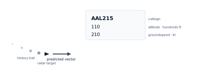
Radar shows you where an aircraft was a moment ago, as a symbol that is refreshed once each sweep. Everything else on your screen is information built on top of that one dot.
Each target carries a data block with its callsign, altitude and groundspeed. Read the altitude first. The scope is a flat picture of a sky that has three dimensions, so two targets that look about to collide on the screen may be a thousand feet apart and no problem at all.
Behind each target is a history trail, a short string of dots marking where the aircraft has been. Ahead of it points a predicted vector, marking where it will be shortly if nothing changes. You will see a turn in the history trail before you see it anywhere else, because the trail bends before the groundspeed and position in the data block have caught up.
Under all of this is the video map: your sector boundary, the airport, the fixes and the final approach course. The airspace on it is labeled as well as drawn. Airspace comes in classes lettered Alpha through Golf, and the United States does not use class Foxtrot. Alpha through Echo are controlled airspace, each with its own rules, and Golf is everything left over, which is uncontrolled. The manual requires the letters to be spoken in the phonetic alphabet so that a pilot does not mistake one class for another:
A, B, C, D, E, and G airspace are pronounced in the ICAO phonetics for clarification.
Over a shift you will name fixes and runways far more often than airspace classes, and the habit is the same for all of them. Say the label the way the map draws it, so there is nothing for the pilot to mishear.
Controllers call the sum of this reading the picture. Having the picture means knowing, without staring at the screen, roughly where everything on your frequency is and what each aircraft needs next. You build it by scanning: your eyes move in a loop across every target instead of settling on the one that looks interesting. The common beginner mistake is to fix on that one aircraft while two others that seemed routine close on each other. Keep scanning, because the picture is out of date within seconds of your last look.
In the Sim
In ATC Simulator, every number in this chapter is live on your scope and your radio. The data block under each aircraft shows its callsign, its altitude in hundreds of feet and its groundspeed in knots, with a trend arrow that shows whether it is climbing or descending. History trails and predicted vectors are drawn as this chapter describes them, and the video map underneath is Bayview's own sector boundary, the arrival fixes and the final approach courses to runways two five right and three three. Every command you speak on your one voice frequency, one two four point six, is graded on these units: headings as three digits, altitudes in feet, speeds in knots. The vocabulary is scored under phraseology in the same way as the instruction itself.
You will never issue an altimeter setting. A real controller passes the local pressure so that every pilot's altimeter reads the same feet; the sim handles altimeter settings and the transition to flight levels for you, since Bayview Approach's sector sits below the altitudes where that comes up. The flight level concept still matters, because it is the vocabulary Cascade Center and the sectors above your ceiling use every day. Later chapters use the feet, knots and headings from this chapter without stopping to explain them again, and that includes the separation minimums of three nautical miles or 1,000 feet, which chapter seven turns into a skill of its own.